
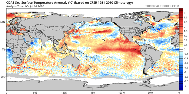
Sea surface temperatures, compared to average, for July 8, 2026. Note the bright reds off the western coast of South America. Those above average ocean temperatures is El Nino, and helps to reduce the amount of named storms this hurricane season in the Atlantic Ocean. Via TropicalTidbits.
By Joe Martucci
A rapidly strengthening El Nino – one that could be the strongest on record – is helping to make the Atlantic hurricane forecast much quieter than usual. That is good news for New Jersey, but it does not mean the coast is in the clear.
I spoke with Levi Silvers, a research scientist at Colorado State University, on our Tidal Flooding Talk podcast from the New Jersey Coastal Coalition. New episodes come out Tuesday evenings.
Silvers said Colorado State University lowered its hurricane forecast again during its July 8 update. The forecast now calls for nine named storms, four hurricanes and one major hurricane (Category 3, 4, or 5) this season. That is below average in all three categories.
Colorado State uses the 1991 to 2020 average, the same time period used by NOAA’s National Hurricane Season.
The main reason for the quieter forecast is El Niño in the Pacific Ocean.
El Niño is a large weather pattern that has to do with water temperatures in the Pacific Ocean along the equator. When the water is colder than average, it’s called La Niña. When it is warmer than average, it’s El Niño.
However, its impacts spread far from there. During many El Niño years, stronger wind shear, or change in wind direction with height, develop high above the Atlantic Ocean and Gulf of Mexico.
Wind shear is bad news for tropical storms and hurricanes. Tropical systems need to stand tall and stay organized. When winds change direction with height, storms can get tilted, stretched or torn apart.
Silvers said that is what Colorado State expects this year.
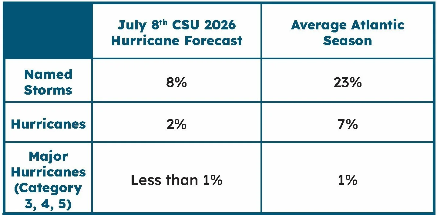
The likelihood of a tropical system impacting NJ in 2026, compared to average.
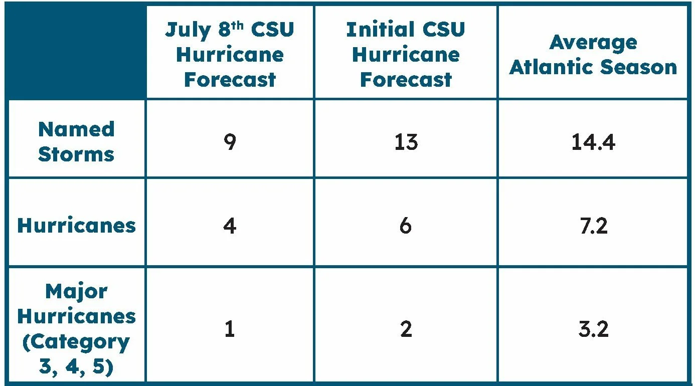
The Colorado State University Hurricane Forecast at different points of 2026, compared to average.
“As things start to form, they tend to get pulled apart,” Silvers said.
Sea surface temperatures are also playing a role. Silvers said the Atlantic Ocean is not as warm as it was in recent years. Warm ocean water is the fuel for tropical storms and hurricanes, needing to be at least 79 degrees for tropical development. When the water is not as warm, storms have less energy to work with.
For New Jersey, the forecast is mostly encouraging.
Colorado State also looks at the chance of a tropical system impacting specific coastal areas. Silvers said New Jersey normally has about a 23% chance of being impacted by a named storm somewhere along the coastline during hurricane season. This year, Colorado State puts that chance at 8%.
That is less than half of the normal risk. Still, 8% is not zero.
He also said the chance of New Jersey being impacted by a hurricane is 2%.
That is welcome news, especially for coastal communities such as Avalon and Stone Harbor that watch every storm during the heart of hurricane season. However, New Jersey does not need a direct hit from a major hurricane to have problems.
A storm passing offshore can still bring coastal flooding, beach erosion, dangerous surf and rip currents. A weaker tropical storm or leftover tropical moisture can also bring heavy rain and freshwater flooding. Sometimes, the worst impacts here come from the tidal flooding, not wind. Just last year, Hurricane Erin brought the most severe summertime flooding on record for much of the South Jersey shoreline, but without a drop of rain.
In Avalon, our in-house Tidal Flooding Dashboard through our ShorelySafe program shows that the Aug. 21, 2025 tidal flood was the 10th highest of all time. The tide gauge peaked at 7.83 feet above mean lower low water. That’s considered a major flood stage by NOAA, sitting right below the flooding experienced on Oct. 27, 2018.
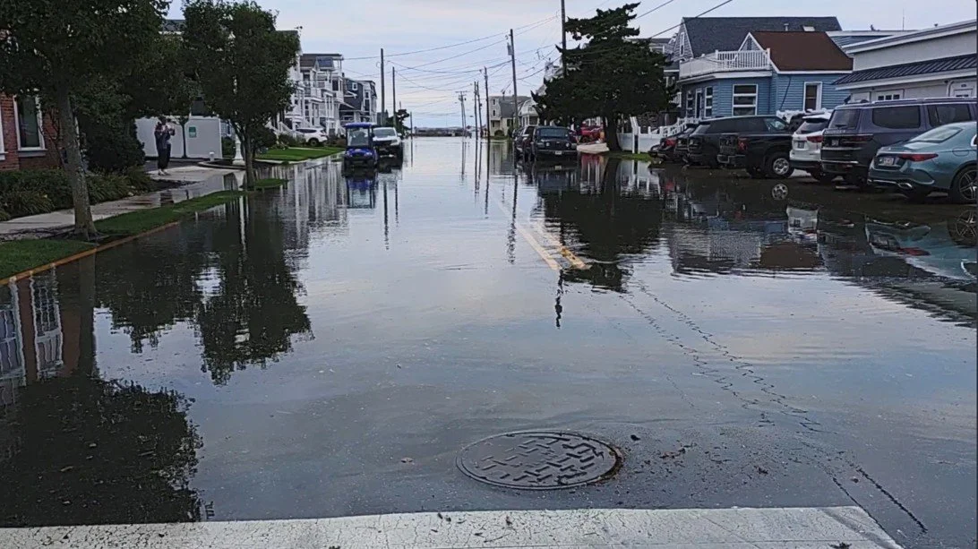
Flooding in Avalon during Hurricane Erin on Aug. 21, 2025. It was the highest summertime tide on record for the Borough.
The biggest wild card is the Atlantic Ocean itself. Silvers said trade winds could still change in a way that allows parts of the tropical Atlantic to warm quickly. If that happens, storms could have more energy available, even with El Niño creating wind shear.
Right now, though, Silvers said that does not appear likely.
Colorado State will issue another hurricane season update in early August. After that, updates will come more often as forecasters watch conditions closer to the peak of the season.
For New Jersey, the message is simple: this hurricane season looks quieter than usual, but the coast should still stay ready.
It only takes one storm to turn a quiet season into a serious one.